MTS-CAD
The software for data preparation
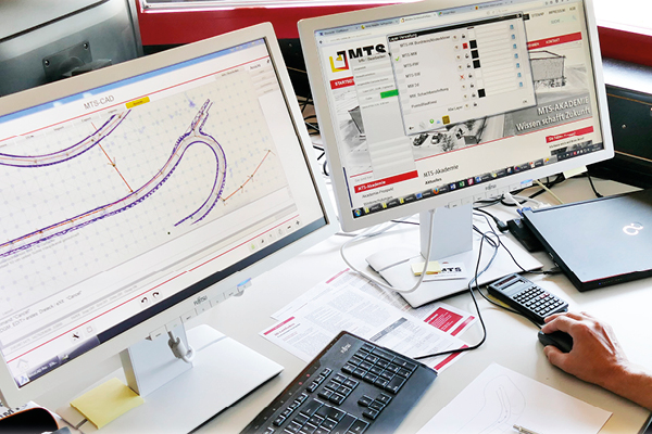
CAD plans, which are usually available in DXF format, form the basis of data preparation. The MTS-CAD concentrates on the necessary degree of functions required in data preparation for civil engineering. This is essentially a data management and display tool for visualising measurement data.
The benefits
- Quick and easy to use - requires little familiarisation
- Map material can be created for construction projects
- Display of sewers and pipelines as 3D lines
- Check and supplement existing planning documents
- Planning errors are detected before the construction site comes to a standstill
- Determined lengths, areas and volumes help with the requirements specification during construction
- Lengths, areas and volumes yield traceable and verifiable accounting documentation
- No CAD knowledge required
![]() Inclusive volume assistant -> more at 3D machine control
Inclusive volume assistant -> more at 3D machine control
The benefits
Saves the need for preliminary staking by a surveyor
Advanced stake-out functions such as indirect measurement and other additional functions relevant to construction practice
Each work step is documented - complete accounting documentation
The foreman can personally perform stake-outs during construction - at the appropriate time
Precise surveying of the terrain facilitates the exact determination and allocation of the moving masses
The assistants & tools

KOSTENLOS!
- sortiert, filtert oder reduziert die Messdaten einer kompletten Baustelle
- verarbeitet das Messprotokoll weiter
- grafische oder tabellarische Anzeige und Ausgabe der aufgenommenen Daten
- erleichtert die Bereinigung und Zusammenführung der Messdaten für die MTS-PILOT Anwendungen
- Aufbereitung für die Weiterverarbeitung mit dem 3D-Planmanager oder anderen CAD-Programmen
- speichert neuen Datensatz in verschiedenen Formaten
- Betrachtung und Weitergabe von ausgewählten Punkten oder Linien aus einem bestehendem Gewerk
- identifiziert und bereinigt doppelte Daten
Unter doku.mts-online.de haben Sie die Möglichkeit, das Setup per Mausklick herunterzuladen.

- Ausgabe als PDF mit Bemassung
- Fertige Abrechnungspläne auf Knopfdruck
- Aufteilen der Aufmaße nach eigenen Vorgaben z.B. Kostenträger oder Ort
- stellt Messdaten sinnvoll zusammen, z.B. nach Ort, „HA Nr.4“ oder dem Inhalt „Randsteine“
- Prüfbare und nachvollziehbare Aufmassunterlagen
- Der Auftraggeber braucht zur Prüfung und Übernahme keine spezielle Software
- Anbindung an den ISL-Baustellen-Manager
- 3D CAD program, cutting of layers, management of tools, create and edit DTM, read in and output points, create and edit measuring points, simple meshing of digital terrain models, volume calculation, 100% compatible with MTS-PILOT programs
Das Rundum-Sorglos-Paket für die digitale Baustelle
Mit dem neuen Software-Pflegevertrag erhalten Sie ein Rundum-sorglos-Paket mit zusätzlichen Leistungen rund um Ihre MTS-PILOT-Software. Eine ausführliche Beschreibung der einzelnen Leistungen finden Sie untenstehend.
Alle Vorteile im Überblick
- Kostenlose Updates & Upgrades
- Ihre gesamte Baggerflotte bleibt „up to date“
- Nahtloses Weiterarbeiten nach Upgrades
- Ein Ansprechpartner, der Ihre Sprache spricht
- Minimale Reaktionszeiten beim Support
- Erweiterte Supportleistungen sind inbegriffen: Baustelleneinrichtung bei Auslieferung, wiederholte Einweisungen, kostenlose Support-Hotline etc. Keine Versionskonflikte
- Das „Extra-PLUS“: 25 % Rabatt auf alle MTS-Seminare der www.MTS-Akademie.de
3D-Planmanager (Datenaufbereitung)
- DWG/PDF-Anbindung
- integrierter PAL Manager zur Auswertung von MTS-PILOT-Messdaten
- Darstellung von Kanälen und Rohrleitungen als 3D-Linien
- Einfachstes Erstellen von digitalen Geländemodellen aus Punkten und Linien
- Vorhandene Planunterlagen prüfen, ergänzen oder ausmisten
- 100% kompatibel mit MTS-NAVI und MTS-GEO
- für Bauleiter und Poliere, die sich in der digitalen Baustelle nicht abhängen lassen wollen
2.100,- € Software Lizenz (einmalige Kosten)
+ 42,- € Pflegevertrag (Support & Upgrades | monatliche Kosten | mind. 2 Jahre Laufzeit)
Der 3D-Planmanager enthält den PAL Manager sowie den Volumenassistenten und kann mit dem Baugrubenassistenten kombiniert werden.

How we can support you:
- Support
- Training
- Content check
- Data conversion
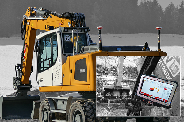
Small and medium-sized construction companies are often lacking the necessary mix of manpower, expertise and software equipment for 3D data creation. MTS therefore offers support, independent of the manufacturer, for the implementation of your planning documentation for excavator control.
This includes all services from pure support, the complete realisation of the data to the training of your employees. The investment pays off because every hour that is invested wisely in data preparation reduces the surveying workload and significantly accelerates the construction process.

